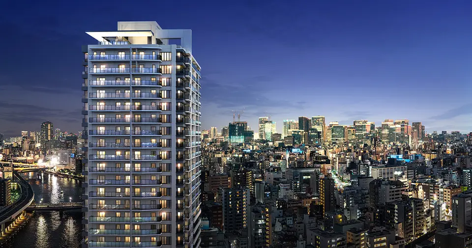
Architectural rendering|This rendering was published in the developer's official materials. The completed building may differ due to plan changes or other factors. Source:Developer's official website (verified 2026-10-15)
BRILLIA TOWER ASAKUSAYANAGIBASHI
Tokyo 23 Wards, Taito Ward, Yanagibashi 2-chome. Above ground: 34 floors, Scheduled for completion in 04/2027。
This building is under construction. Unpublished unit counts are shown as “Unconfirmed”; other items are shown as “—”.
Brand: Brillia Tower (Tokyo Tatemono Co., Ltd.)
Total units 267 units
What do you think of this building?
User responses (0 people). This is not a TOWERS.SELECT rating.
Building information last updated
BRILLIA TOWER ASAKUSAYANAGIBASHI is a high-rise condominium in Tokyo, Taito Ward, Yanagibashi 2-chome with 34 floors above ground, 267 total units.Scheduled for completion in 4/2027.Because the building is not yet complete, listings, current amenities, and valuations are not shown.
TOWER DOSSIER / 12 FACTS
12-data-point building card
This single card combines verified building-register facts with units identified as currently listed. Unverified information is not presented as “none.”
Building-register values are verified against a source for each field. Listing totals may combine buildings on the same site and use asking prices, not transaction prices. “No listing summary” does not prove that an amenity or listing does not exist.

Reviews, Feedback & Message Board
These posts are from residents and prospective residents. This site has not verified contributors’ residency or their claims. Posts undergo automated screening before publication.
Latest reviews and feedback
No reviews have been published yet.
34View from floorPredicted view(Video)
In the View Simulator, 34A recording looking 360° around from the height of floor October 12, 2026). This is a reproduction using Google Maps' 3D city model and does not show the actual view from a unit, a future view, or weather conditions.This building is not yet complete and is not included in the 3D model.
Watch on YouTube For other floors and directions, use theView Simulator to explore the view.
View Simulator Members only

Construction watch
Announcements, completion-schedule changes, and submitted construction photos are shown in date order without speculation.
- Scheduled Completion Scheduled for completion in April 2027
Construction progress photos
No construction progress photos have been posted yet. If you pass the site, consider submitting the first one.
Submit a construction progress photo View All High-Rises Under Construction →
Attach the photo to a review and select “Construction progress” as the type. Photograph it from a public road or another place outside the site without obstructing the work.
Overview
| Item | Value |
|---|---|
| Building | BRILLIA TOWER ASAKUSAYANAGIBASHI |
| Location (neighborhood) | Yanagibashi 2-chome |
| Location (street address) | Tokyo, Taito Ward, Yanagibashi 2-chome, 4-2 |
| Above-ground floors | 34 floors above ground |
| Completion date | April 2027 |
| Total units | 267 units |
| Land rights | Freehold |
| Structure | RC See the cited source for the official entry |
| Zoning | Commercial zone |
| Site area | 2,366.65㎡ |
| Building footprint | 1,108.56㎡ |
| Total floor area | 27,274.43㎡ |
| Management arrangement | See the cited source for the official entry |
| Property management company | See the cited source for the official entry |
| Seller | See the cited source for the official entry |
| Architect | See the cited source for the official entry |
| General contractor | See the cited source for the official entry |
| Structural earthquake protection | Base isolation |
LOCATION
Planned site map
LocationTokyo, Taito Ward, Yanagibashi 2-chome, 4-2
Loading map.
Amenities and management
This information has been verified from cited sources. “Unverified” does not mean that an amenity is unavailable. Shared complex amenities may not be located within this tower.
| Direct station access | Unverified |
|---|---|
| Structural earthquake protection | Base isolation (Building) |
| Parking capacity | 72 parking spaces (Building) |
| Parking conditions | Unverified |
| Property management company | Unverified |
| Management system and staffing | See the cited source for the official entry (Building) |
| Repair plans and records | Unverified |
| Guest room | Unverified |
| Lounge | Lounge (Building) |
| Gym | Unverified |
| Concierge | Unverified |
| Parcel lockers | Parcel lockers (Building) |
| 24-hour trash disposal on every floor | Waste collection area on each floor (Building) |
| Interior corridors | Unverified |
Shared amenities
| Lounges and views |
|
|---|---|
| Daily-life services |
|
| Parking and bicycle parking |
|
Parking and bicycle parking
| Category | Spaces | Monthly Amount | Size limits and notes |
|---|---|---|---|
| Parking | 72 parking space | JPY 36,000–JPY 49,000/month | |
| Motorcycle parking | 2 parking space | JPY 10,000/month | |
| Moped parking | 12 parking space | JPY 7,000/month | |
| Bicycle parking | 387 parking space | JPY 700–JPY 1,000/month |
Parking capacity does not guarantee availability or usage rights. Check management rules and related documents for fees, vehicle restrictions, eligibility, and reservations. Amenities, services, and management arrangements may have changed since the retrieval date.
Frequently asked questions about BRILLIA TOWER ASAKUSAYANAGIBASHI
- Which companies handle Construction, Architect, Developer, Management for BRILLIA TOWER ASAKUSAYANAGIBASHI?
- Construction: the company named in the cited source, Architect: the company named in the cited source, Developer: the company named in the cited source, Management: Tokyo Tatemono Amenity Support Co., Ltd..
- What shared facilities are available at BRILLIA TOWER ASAKUSAYANAGIBASHI?
- Lounge are available.
- Can residents dispose of garbage at any time at BRILLIA TOWER ASAKUSAYANAGIBASHI?
- There is a garbage collection area on every floor, available 24 hours a day.
- How many parking spaces does BRILLIA TOWER ASAKUSAYANAGIBASHI have?
- the parking facility has 72 parking spaces. The fee is JPY 36,000–JPY 49,000/month. Availability and rates may change; please check with the property management company.
- Does BRILLIA TOWER ASAKUSAYANAGIBASHI use base isolation or seismic response control?
- Structural system: Base isolation.
Asking prices at nearby completed towers
Because this building is not yet complete, current listings and valuations are not shown. Below are asking prices for units currently for sale in nearby completed buildings. They are neither transaction prices nor planned prices for this building.
| Nearby completed buildings | Straight-Line Distance | Completed | Number of Floors | Median Asking Price per Tsubo | Units for sale |
|---|---|---|---|---|---|
| TOKYO AINSU RIVERSIDE TOWER | 990m | 11/2004 | 24 stories above ground | JPY 5,347,000/tsubo | 3 unit |
| CRESCENT TOKYO VIEW TOWER | 1,060m | 2/2005 | 24 stories above ground | JPY 5,598,000/tsubo | 3 unit |
Buildings within 1,500m with at least 3 units for sale, ordered by distance. Differences in size, floor, orientation, and building age are not adjusted for.
Taito Ward has 38 units listed in completed high-rises, with a median asking price per tsubo of JPY 7,887,000/tsubo.
Including this building, 11 tower condominiums are scheduled for completion in Tokyo 23 Wards in 2027; buildings with published unit counts total 4,395 units units.Supply outlook by scheduled completion year
Plan details in filings and permits
Values copied from public filing and permit records mechanically matched to this project by ward, neighborhood, number of floors, and expected completion date. They reflect the plan when filed and may differ from the building details above or have since changed.
| Item | As stated in the record | Source |
|---|---|---|
| Name in filing | BRILLIA TOWER ASAKUSAYANAGIBASHI | Cited source |
| Location | See the cited source for the official entry | Cited source |
| Number of Floors | 34 stories above ground | Cited source |
| Height | Approx. 121.78 m | Cited source |
| Use | Multi-unit residential building | Cited source |
| Total units | 270 units | Cited source |
| Site area | 2,366.65㎡ | Cited source |
| Building footprint | 1,111.87㎡ | Cited source |
| Total floor area | 27,428.50㎡ | Cited source |
| Zoning / district | See the cited source for the official entry | Cited source |
| Public open space (effective area) | 1,201.93㎡ | Cited source |
| Additional filing detail | 2022-05-26 | Cited source |
Comparable transactions near the development site(Yanagibashi 2-chome, Built in 2027)
No comparable transactions matching this building’s criteria (neighborhood and year built) were found.No transaction matched the ward, neighborhood, and completion year
LAND PRICE
Land Prices Near the Development Site
View the Land-Price Map for Around BRILLIA TOWER ASAKUSAYANAGIBASHI
See how nearby land is valued.
Use the map to check each location and explore prices and their changes.
Official Land Prices · 2026 as of January 1 · Nearby3Location
Indicative nearby land value588.8 ¥10,000/tsubo178.1¥10,000/m²
Average weighted more heavily toward nearer points
Change from previous year18.7 %
Compared with the same points one year earlier · 3Location
5-year annual average9.2 %
Five-year change converted to an annual rate · 3Location
Commercial land in 3 reference points used.Prices for each point are listed below. 366.9〜1,352.1 ¥10,000/tsubo。Compare locations and land uses on the map to understand the average.
This is the assessed value per tsubo of land (1 tsubo = 3.30579㎡).This does not represent the assessed value of the building's site or the condominium's sale price.
Loading map. Point locations and prices are also available in the list.
buildings This building planned site1 Official land pricesRef. 1 Reference survey
Select a number to view point details. Lines and distances from the building are straight-line measurements.
Official land prices 2026YearJanuary 1
1005-018Commercial land
Official survey location: 35.699154, 139.789453
366.9 ¥10,000/tsubo111.0¥10,000/m²From building 123 m
Year-on-year 18.6%5-year annual average 9.5%
2005-007Commercial land
Official survey location: 35.697581, 139.786121
1,352.1 ¥10,000/tsubo409.0¥10,000/m²From building 349 m
Year-on-year 19.6%5-year annual average 9.1%
3005-002Commercial land
Official survey location: 35.695072, 139.792397
433.1 ¥10,000/tsubo131.0¥10,000/m²From building 406 m
Year-on-year 18.0%5-year annual average 8.5%
Reference: Prefectural Land Price Survey · 3Location
Prefectural Land-Price Survey 2025YearJuly 1
Because the survey date and locations differ, these values are excluded from the official land-price average above.
Ref. 1005-008Commercial land
Official survey location: 35.697581, 139.786121
1,223.1 ¥10,000/tsubo370.0¥10,000/m²From building 349 m
Year-on-year 17.1%5-year annual average 6.7%
Ref. 2005-012Commercial land
Official survey location: 35.696088, 139.786934
446.3 ¥10,000/tsubo135.0¥10,000/m²From building 353 m
Year-on-year 17.4%5-year annual average 7.9%
Ref. 3005-013Commercial land
Official survey location: 35.698561, 139.784573
459.5 ¥10,000/tsubo139.0¥10,000/m²From building 486 m
Year-on-year 17.8%5-year annual average 8.2%
How has the nearest point's price changed?
Location1(005-018) over time. Unlike the “Indicative nearby land value” above, this tracks one consistent point.
Land-price trend at location 1
¥10,000/tsuboView annual prices in a table
| Year | Price (¥10,000/tsubo) |
|---|---|
| 2002 | 183.5 |
| 2003 | 171.6 |
| 2004 | 162.0 |
| 2005 | 156.7 |
| 2006 | 156.7 |
| 2007 | 176.9 |
| 2008 | 201.3 |
| 2009 | 183.8 |
| 2010 | 170.2 |
| 2011 | 166.6 |
| 2012 | 162.6 |
| 2013 | 162.6 |
| 2014 | 166.0 |
| 2015 | 168.9 |
| 2016 | 174.2 |
| 2017 | 182.8 |
| 2018 | 193.4 |
| 2019 | 211.2 |
| 2020 | 238.3 |
| 2021 | 233.1 |
| 2022 | 236.4 |
| 2023 | 246.0 |
| 2024 | 269.1 |
| 2025 | 309.4 |
| 2026 | 366.9 |
How to Read the Figures, Calculation Method, and Sources
- Indicative nearby land value
- Prices for the listed points are weighted by the inverse of each point's stored distance from the building. For points with verified coordinates, map and list distances are straight-line measurements from the building's current coordinates. If those coordinates were updated, they may differ from the distances used in the calculation. This is not a site valuation adjusted for land use or road conditions.
- Change from previous year
- Year-on-year changes at the same locations are weighted by distance. “—” means no comparable value is available.
- 5-year annual average (CAGR)
- This converts the change since five years ago into an annual rate, assuming the same rate each year. It is not the total five-year increase. Only comparable points are weighted by distance.
Official land prices: search radius 2,000 m, 3locations.
Prefectural Land-Price Survey: search radius 2,000 m, 3locations.reference average 736.8 ¥10,000/tsubo, year-on-year 17.4%, 5-year annual average 7.5%。
Hazard projections and surroundings (official data)
Planned siteResults from matching the coordinates against public data from Japan's Ministry of Land, Infrastructure, Transport and Tourism. Being outside a projected zone and having missing or unavailable data are shown as separate states. No value does not mean the location is safe.
Hazard projections
Check official projections for flooding, landslides, and other hazards.
| Liquefaction tendency | High liquefaction susceptibilityLandform classification: Delta and coastal lowland · level 2 of 6 (1 is the most susceptible to liquefaction) General tendency based on the 250 m grid landform classification; ground improvements and foundation specifications are not reflected. Prepared by TOWERS.SELECT using MLIT liquefaction susceptibility map based on landform classification(retrieved 2026-09-27) |
|---|---|
| Storm-surge inundation projection | 0.5 m to under 1 mTarget year: 2020 Maximum inundation depth among the projected zones overlapping the coordinates of Planned site. Prepared by TOWERS.SELECT using MLIT National Land Numerical Information: Storm Surge Inundation Assumption Areas(retrieved 2026-09-27) |
| Flood inundation projection (maximum assumed scale) | 0.5 to under 3.0 m (above-floor flooding to the first floor)Rivers covered: Arakawa River Highest rank among the river-specific projections overlapping the coordinates of Planned site. Prepared by TOWERS.SELECT using MLIT National Land Numerical Information: Flood Inundation Assumption Areas(retrieved 2026-09-27) |
Zoning
Urban-planning categories governing residential, commercial, and other land uses.
| Zoning | Commercial zoneFloor-area ratio: 500.0% / Building coverage ratio: 80.0% These are the designated floor-area and building coverage ratios, not the actual values or any relaxations applied to this building. Prepared by TOWERS.SELECT using MLIT urban-planning GIS data: Land-use zoning(retrieved 2026-09-27) |
|---|---|
| Fire-prevention and quasi-fire-prevention districts | Fire prevention district Prepared by TOWERS.SELECT using MLIT urban-planning GIS data: Fire-prevention districts(retrieved 2026-09-27) |
Passenger traffic at the nearest station
See the station's usage level and annual changes.
the station named in the cited source stations (Toei Asakusa Line / Sobu Main Line) is a straight-line distance of 272 m. 2023 annual passenger traffic was 153,123 passengers per day.
Daily ridership at the station named in the cited source Station
people/day| Year | Passenger traffic (people/day) |
|---|---|
| 2011 | 158,064 |
| 2012 | 158,673 |
| 2013 | 161,103 |
| 2014 | 163,603 |
| 2015 | 165,457 |
| 2016 | 167,058 |
| 2017 | 168,594 |
| 2018 | 171,622 |
| 2019 | 170,502 |
| 2020 | 115,944 |
| 2021 | 122,920 |
| 2022 | 140,436 |
| 2023 | 153,123 |
Values combine multiple lines at the same station. Distance is measured in a straight line to the station, not as walking time.
Prepared by TOWERS.SELECT using MLIT National Land Numerical Information: Station Passenger Counts(retrieved 2026-09-27)
Projected local population
A projection of how the population within the 250 m grid cell may change.
Planned site is in a 250 m grid cell with a projected population of 2,055 people in 2025 to in 2050: 2,377 people(+15.7%)。
Projected population in the 250 m grid cell
people| Year | Projected population |
|---|---|
| 2025 | 2,055 |
| 2030 | 2,138 |
| 2035 | 2,196 |
| 2040 | 2,247 |
| 2045 | 2,313 |
| 2050 | 2,377 |
Projections based on the 2020 census. Areas first occupied after 2020 may not be reflected.
Prepared by TOWERS.SELECT using MLIT National Land Numerical Information: 250 m Mesh Future Population Estimates(retrieved 2026-09-27)
Reference information only. It is not guaranteed for use in important-matters explanations, building applications, or other official procedures (MLIT Real Estate Information Library Terms, Article 3(4)).
Nearby buildings
Buildings in the same chōme are grouped under Yanagibashi 2-chome .
English and alternate names
English names
- BRILLIA TOWER ASAKUSAYANAGIBASHI
Alternate names
- Brillia タワー 浅草柳橋 Japanese alias
- ブリリア Tower 浅草柳橋 Japanese alias
- ブリリア タワー 浅草柳橋 Japanese alias
This page lists English and kana variants derived mechanically from the official name, along with aliases verified to refer to the same building. Differences in character width, spaces, punctuation, middle dots, and long vowel marks are normalized automatically when searching.